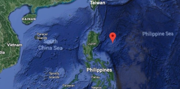

A new Island has appeared after some heavy seismic activity in the Apolaki Caldera in the Philippine Sea.
This area of the Pacific sea bottom, formerly known as the Benham Rise; now known as the Philippine Rise, is an oceanic plateau roughly 200 miles North East of Luzon has been the subject of a great deal of interest in the past few years:
The Benham Rise, officially known as the Philippine Rise, is a seismically active undersea region and extinct volcanic ridge located in the Philippine Sea approximately 160 to 210 miles North East of Luzon.
Under the Philippine Sea lie a number of basins including the West Philippine Sea Basin, inside of which is located the Central Basin Fault (CBF). The Benham Plateau is located in the CBF and its basement probably is a micro-continent. Several scientific surveys have been made on the feature to study its nature and its impact on tectonic subduction, including one about its effects on the 1990 Luzon earthquake. The Philippines claimed this feature as part of its continental shelf in a claim filed with the United Nations Commission on the Limits of the Continental Shelf on April 8, 2009, and which was approved under the United Nations Convention on the Law of the Sea (UNCLOS) in 2012. It is designated as a "protected food supply exclusive zone" by the Philippine government in May 2017. Mining and oil exploration is banned in the Benham Plateau as a protected area. On May 16, 2017, Executive Order No. 25 was signed, renaming the feature to “Philippine Rise”.
Republic of the Philippines lodged a partial territorial waters claim with the United Nations Commission on the Limits of the Continental Shelf in relation to the
continental shelf in the region of Benham Rise. It was submitted as part of petition expanding the archipelago's baselines and exclusive economic zone
through a law that also included other claims involving disputed territories of the Kalayaan Islands (Spratly Islands) and Scarborough Shoal.
Although the landform, in itself, is not disputed, the petition still received some criticism from China.
China released a statement saying that they do not recognize the ruling and that China seeks to claim the Benham Rise in the near future as it is part of a so-called
'Chinese second-chain islands'. However, there are no existing islands within the Benham Rise.
After Chinese survey ships were spotted in the region in 2017, Philippine president Rodrigo Duterte suggested that the plateau be renamed to emphasize
the Philippine's sovereignty over the area.
Soon after, the Department of Foreign Affairs announced plans to come up with a new name.
In May 2017, the Philippine government officially adopted the name "Philippine Rise" for the feature and designated the area as
a "protected food supply exclusive zone" and prohibited mining and oil exploration in the Benham Plateau, angering China in the process.
China maintained that the Philippines has no sovereign rights or sovereignty over the Benham Rise
despite a UN-backed international ruling in 2012 that says otherwise.
On February 16 2018, the Philippine government announced that they have sent military personnel into Cagayan Valley to guard the Rise.
Two days later, it was revealed that China intends to name a total of 142 features.
On February 26, the Department of Foreign Affairs stated during a Senate investigation that China actually surveyed the Rise in 2017
without any Philippine-issued permit, citing the lack of capability to detect illegal entry.
A Pilipino survey ship in February 2020 discovered the world's largest caldera with a diameter of 150 kilometers. It was discovered by Jenny Anne Baretto,
a Filipina marine geophysicist. She was named it Apolaki, the after mythical Filipino god of the sun and war.
A year later…
A new Island has appeared after some heavy seismic activity in the Apolaki Caldera in the Philippine Sea.
The Island was first discovered by satellites surveying the area after the earth quake. The Philippine Navy sent a Recon Helicopter and discovered a large island shrouded in clouds and mist. The Helicopter was then lost when it attempted to enter the mist.
The Philippine government called on its allies for help while their navy prepared a rescue mission. The Chinese and Russian navies sent a ship as well to investigate.
Visitors that arrived to investigate the Island:
1st Philipino Navy UH-1-ER Recon Helicopter
2nd USN DDG USS John Fin DDG-113
3rd PLAN DDG Nanchang
4th JMSDF DDG Atago
5th RFS DDG Adm. Peteleyev
ANOMALIES:
1. The mist downs drones, helicopters, and planes. They all disappear in the mist.
2. The mist only covers the entire Island at night. The center of the Island stays in mist in the day while the edges become visible.
3. Going inland past a 10 to 50 meter beach area the visible areas of the Island are covered with 70 to 100 meter tall Palm trees.
CLASSIFIED: After action report of E3 Seaman Medic Liz Altman USN of the USS John Fin
Ensign John Doeman USN: Ensign Doeman was in charge of the first USN landing party on Haidongquing Island. He, myself and Andrew Durman, an Australian Geologist flown up from Sydney University to help the USN on its initial investigation of Haidongquing Island. We landed after the mist receded from the beach area in the North East quarter of the island near a grassy and open area that extended several kilometers in from the beach. we had tents and survival gear adequate for a three day survey mission. We explored the grassy area and found remnants of very old (Durman believed hundreds of years old) structures. Only the stone founations were left mostly buried in the grass.
The largest of the foundations, a stone platform for roughly 30 meters square was devoid of vegetation and even had some faded writing on the stones.
妖怪
and
, phantom, strange apparition and monster.
Before preparing camp near the beach for the night we found one more piece of faded writing, again in Japanese on a large monolith on the edge of the
underbrush of the Palm tree jungle:
火
That night, the mist descended all the way to the waves of the shore and beyond. All our electronics failed except the simplest ones like flashlights.
We observed a Colossal shadow off shore and the sounds of a large ship. Durman thought he heard Japanese but Ensign Durman said that both the Fin and the Atago were well over the horizon, at least 30 miles off shore and that it couldn't be the Japanese destroyer.
It was then that we first heard another sound, but this time from inland, from the area of the ruins. It was the sound of a large engine. Moments later we were
Attacked by a huge Armor Fighting vehicle, larger than an Abrams. It's front was 30 feet across, and it mounted machine guns, a cannon, and flame throwers.
We were separated in the darkness and mist. I survived by wading out into the surf. In the morning I returned to camp to find it destroyed and the Ensign and Durman missing. I was able to find our radio, which amazingly wasn't in bad shape. Oddly it was functional now. I called in and the Fin sent a Seahawk to pick me up.
Back to A Dark Matter Story Index